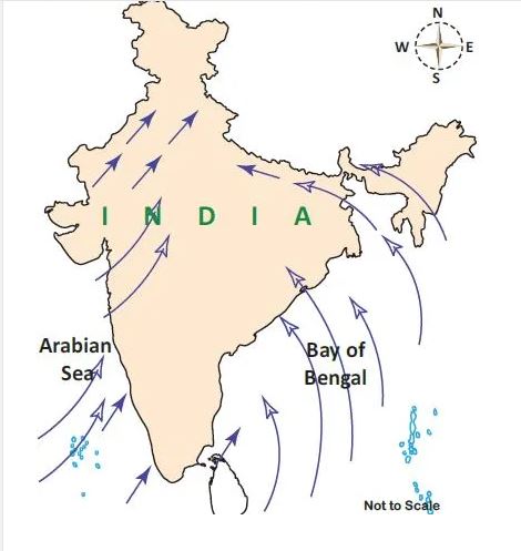
Direction of South West monsoon in India
The Bay of Bengal wind moves to northeast India, Myanmar and this wind is trapped by mountain groups such as Khasi, Garo, and Jaintia. This results in the heaviest rainfall in the world, that is Mawsynram located in Meghalaya.
Then it moves to the west, which results in a rainfall decrease from east to west. The southwest monsoon winds in India are responsible for 75% of the Indian rainfall. Tamil Nadu that is located on the leeward side receives less rainfall from this wind.

South west monsoon in India
There occurs a rapid increase of temperature in May over the North-Western plains. This intensifies the low-pressure condition over there.
By early June, this low pressure is enough to attract the trade winds of the Southern Hemisphere, which come from the Indian Ocean.
These Southeast trade winds cross the equator and enter the Bay of Bengal and Arabian sea and catch up in the air circulation over India.
These pass over the equatorial warm currents and bring a lot of moisture. This wind after crossing the equator follows a southwesterly direction. That is the reason it is called Southwest Monsoons.
Rain of Southwest Monsoon starts abruptly. The first result of this rain is it brings down the temperature quickly. This sudden onset of moisture-laden winds is associated with violent thunder and lightning. This is termed as ‘break’ or ‘burst’ of the monsoon.
The burst of monsoon starts in the first week of June in the coastal areas of Kerala, Karnataka, Goa, and Maharashtra. In the internal part of the country, the burst of monsoon gets delayed to the first week of July.
There would be a decline in day temperature from 5°C to 8°C between mid-June and mid-July.
When these winds approach the land, its southwesterly direction is changed by the relief and thermal low pressure over Northwest India. The southwestern monsoon approaches India by two branches:
- Arabian Sea Branch
- Bay of Bengal Branch
Monsoon Winds of the Arabian Sea
The Monsoon winds the starts over the Arabian sea further split into three branches:
First Branch
The first branch is obstructed by the Western Ghats. These winds get on to slopes of western ghats from 900-1200. Then they quickly become cool and as a result, the windward side of Sahyadris and Western Coastal plain gets heavy rainfall between 250 cm and 400 cm.
After crossing the western Ghats, these winds descend and get heated up and as a result humidity of these winds gets decreases. Due to this, the winds cause little rainfall in the east of the Western Ghats.
This region is called the Rain-Shadow region. This is because it receives less rainfall.
Second Branch
Another branch of Arabian sea monsoon winds hits the coast north of Mumbai. This moves along the Narmada and Tapi river valleys.
Then these winds cause rainfall in an extensive area of central India. As a result, the Chotanagpur plateau gets 15 cm of rainfall from this part of the branch.
At last, these winds enter the Ganga Plain and mingle with the branch of the Bay of Bengal.
Third Branch
The third branch of wind hits the Saurashtra Peninsula and Kachchh. Then it passes over Rajasthan and Aravalis and causes only a little rainfall.
In Punjab and Haryana, it joins the Bay of Bengal branch. These two branches reinforced and cause rains in the Western Himalayas.
Monsoon Winds of the Bay of Bengal
The Bay of Bengal branch strikes the coast the Myanmar and southeast parts of Bangladesh. The Arakan Hills on the coast of Myanmar deflect a big portion of the Bengal branch towards the Indian subcontinent.
Therefore the Monsoon enters West Bengal and Bangladesh from the south and southeast direction instead of the south-westerly direction.
From here, this branch splits into two under the influence of the Himalayas and the thermal low is northwest India. It’s one branch moves westward along the Ganga plains reaching up to Punjab plains.
Another branch moves up to Brahmaputra valley in the north and the northeast causing heavy rains.
Its subbranch strikes the Garo, Khasi hill of Meghalaya, Mawsynram that is located on the crest of Khasi Hills. This region receives the highest average annual rainfall in the world.
But during this season, the Tamil Nadu coast remains dry. This is due to two factors:
a. Tamil Nadu coast is situated parallel to the Bay of Bengal of southwest monsoon.
b. Also it lies in the rainshadow area of the Arabian sea branch of the southwest monsoon.
For Tnpsc
The southwest monsoon is the most important feature of the Indian climate. It takes place in the Southern Tip of India Peninsula normally by the first week of June.
South-West monsoon advances along the Konkan coast during starting of June and it covers the whole country by July 15.
The global phenomenon El Nino influences the South West Monsoon. In North India, the temperature reaches almost 46-degree Celsius before the southwest monsoon or rainy season.
There occurs a “Burst of Monsoon”, which is termed as Break, which is a sudden approach of monsoon wind over southern India with Thunder Showers.
This show reduces the temperature of the country.
South West Monsoon Winds
The monsoon wind that is the southern tip of India’s landmass gets separated into two branches.
One branch starts from the Arabian Sea and Another Branch starts from the Bay of Bengal. The one from the Arabian sea provides heavy showers to the west coast of India and is located on the west ghats windward side.
The other part towards the north hits the Himalayan Mountains and brings heavy rainfall in the North.
Rajasthan and western parts get rain from these winds as the direction of the wind is parallel to the Aravali mountains and there is nothing to hold or intrude the wind.