This article discusses the Indian rivers and their tributaries. It also covers west and east flowing rivers in India and types of rivers in India.
Rivers in India
Rivers in India is an important topic in Civil services, often a number of questions asked from its topic. There are seven major rivers namely Indus, Brahmaputra, Narmada, Tapi, Godavari, Krishna, and Mahanadi. Along with its tributaries, it makes the river system of India.
It is important to know the river as about most as India is an agriculture-dependent country, and most of the politics, interstate disputes happen because of it. Also, it is important to know about climate-related to the river, which helps in Agriculture and also disaster management.
A river system or drainage system is an integrated system of tributaries and a trunk stream that collects and drains surface water into the sea, lake, or some other water bodies. The total area drained by a river and its tributaries is known as the drainage basin. The drainage pattern of an area is the result of the geological structure of the respective areas.
It provides irrigation, drinking water, navigation, and helps in power generation to the people.
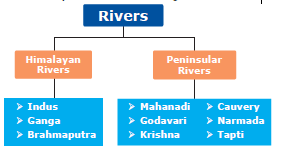
Types of rivers in India
The Indian drainage system is classified into Himalayan, and Peninsular rivers based on their location. Let us see what are Himalayan and peninsular drainage systems?
Himalayan Rivers
Himalayan rivers are found in North India. These rivers originate from the Himalayas. Thereby they are called Himalayan rivers. Himalayan rivers are perennial rivers, that is there is constant water flow throughout the year. Examples of Himalayan rivers are Indus, Ganga, Brahmaputra, etc.
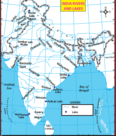
The Indus River System
Indus river is one of the largest rivers in the world. Indus river originates from a northern slope of the Kailash range in Tibet near Manasarovar Lake at a height of 5150 metres above sea level. The length of the Indus is about 2880km but it flows only 709 km in India. The Indus river has a total drainage area extending 11,65,500 sq km in which 321,289 sq km areas are drained in India.
Its flows through the Indian state Ladakh. It flows through Zaskar ranges and creates deep gorges. The river runs through formerly called Jammu and Kashmir, turns south near Chillar, and enters Pakistan.
Indus major tributaries are Jhelum, Chenab (Largest tributary of Indus), Ravi, Beas, and Sutlej. It enters the Arabian Sea.
Indus River Tributaries: East to West Order
| Tributary | Origin | Key Characteristics |
|---|---|---|
| Satluj | Rakas lake near Mansarovar | Antecedent river cutting through Himalayas at Shipki La |
| Beas | Beas kund near Rohtang Pass | Joins Satluj at Harike in Punjab |
| Ravi | Rohtang Pass, Kullu hills | Flows between Dhauladhar and Pir Panjal ranges |
| Chenab | Chandra and Bhaga rivers meet at Tandi | Largest tributary of Indus |
| Jhelum | Sheshnag lake near Verinag, Kashmir | Flows through Wular lake |
| Shyok | Rimo Glacier, Karakoram Range | Flows through Northern Ladakh |
| Gilgit | Northern Areas of Pakistan | Right bank tributary |
| Hunza | Karakoram Range | Joins Indus in Kashmir region |
| Kabul | Afghanistan | Major right bank tributary |
Important Note: According to the Indus Water Treaty of 1960, Indus, Jhelum, and Chenab are under Pakistan’s control, while Ravi, Beas, and Satluj are under India’s control.
The Ganga River System
The Ganga river has the largest drainage system in India. It extends over an area of 8,61,404 sq km in India. The Ganga plain is the densely populated plain in India. The Ganga River originates as Bhagirathi from the Gangotri Glacier in Uttar Khasi District of Uttarkhand, at an elevation of 7010 metres.
The length of the Ganga river is 2525 km. The major tributaries of Ganga from the north are Gomti, Gandak, Kosi, and Ghaghra and from the south, the Yamuna which is the largest tributary of Ganga, Son, Chambal, etc.
The Ganga river is called the Padma in Bangladesh. The Ganga and Brahmaputra together create the world’s largest delta known as Sundarbans in Bangladesh before joining the Bay of Bengal.
Ganga River Tributaries: East to West Order
| Tributary | Type | Origin | Key Characteristics |
|---|---|---|---|
| Mahananda | Left Bank | Darjeeling hills | Last left bank tributary of Ganga |
| Kosi | Left Bank | Nepal, Tibet | Famous for changing river courses |
| Gandak | Left Bank | Nepal Himalayas | Major left bank tributary |
| Ghaghara | Left Bank | Mapcha Chung Glacier, Tibet | Known as Karnali in Nepal |
| Gomati | Left Bank | Pilibhit district | Passes through Lucknow |
| Ramganga | Left Bank | Dudhatoli Hill, Uttarakhand | Flows through Corbett National Park |
| Yamuna | Right Bank | Yamunotri Glacier | Longest tributary, joins at Prayagraj |
| Son | Right Bank | Amarkantak Plateau | Known as ‘Swarna Nadi’ |
| Karmanasa | Right Bank | Kaimur District, Bihar | Forms boundary between Bihar and UP |
| Punpun | Right Bank | Palamu District, Jharkhand | Joins Ganga near Patna |
Unique Features:
- Originates from Himalayan and Plateau regions
- Supports extensive agricultural landscapes
- Critical for North Indian ecological systems
Brahmaputra River System
Brahmaputra river originates from the Chemayungdung Glacier of the Kailash range to the east of Lake Manasarovar in Tibet at a height of 5150 metres about sea level. The Brahmaputra is also known as Tsangpo (Purifier) in Tibet. The total drainage area of the Brahmaputra river is about 5,80,000 sq. km.
Its total drainage area in India is 1,94,413 sq. km. The total length of the Brahmaputra rivers is about 2900 km. The total length of the Brahmaputra river in India is 900 km. Brahmaputra river enters India through a gorge in Arunachal Pradesh namely Dihang. The tributaries of Brahmaputra river are Tista, Manas, Barak, Subansiri etc. Brahmaputra river is called Jamuna in Bangladesh.
Brahmaputra river joins with Ganga river in Bangladesh. The resultant river is called Meghna.
Brahmaputra River Tributaries: East to West Order
| Tributary | Bank | Origin | Key Characteristics |
|---|---|---|---|
| Lohit River | Left | Eastern Tibet | Originates in Zayal Chu range, flows through Mishmi Hills |
| Dibang River | Left | Arunachal Pradesh | Part of left bank tributaries |
| Dhansiri River | Left | Laisang Peak, Nagaland | Runs through Dimapur and Golaghat districts |
| Kopili River | Left | Assam | South bank tributary |
| Manas River | Right | Bhutan | 376 km long, flows through Assam and southern Bhutan |
| Kameng River | Right | Tawang district | Originates near Gori Chen Mountain |
| Subansiri River | Right | China/Tibet | 442 km long, enters Brahmaputra in Lakhimpur district |
| Teesta River | Right | Cholomo Lake, Sikkim | Flows through Himalayan Mountains |
| Sankosh River | Right | Bhutan | Known as Puna Tsang in Bhutan |
Unique Features:
- Originates as Tsangpo in Tibet
- Enters India as Siang/Dihang
- Becomes Brahmaputra after joining Dibang and Lohit rivers
Characteristics of Himalayan Rivers
a.Originate from the Himalayas
b.Long and wide
c.Perennial in nature
d.Unsuitable for hydropower generation
e.Middle and lower courses are navigable
Peninsular Rivers of India
The south Indian rivers are called the Peninsular rivers. Most of the Peninsular rivers originate from the Western Ghats. Peninsular rivers are non-perennial rivers. The peninsular rivers are non-perennial rivers because of large seasonal fluctuation in the volume of water as they are solely fed by rain.
These rivers flow in the valley with steep gradients. Based on the direction of flow, the peninsular rivers are divided into West flowing and East flowing rivers.
East Flowing Rivers
Mahanadi
Mahanadi river originates near Sihawa in the Raipur district of Chattisgarh. It flows through Odisha and its length is 851 km. Seonath, Telen, Sandur, and Ib are its major tributaries. The mainstream of Mahanadi is divided into several distributaries such as Paika, Birupa, Chitartala, Genguti and Nun.
All these distributaries form the Delta of Mahanadi which is one of the largest deltas in India. The Mahanadi empties its water in the Bay of Bengal.
Godavari
The Godavari is the longest among the Peninsular rivers and its length is 1465km. Its drainage area is 3.13 lakh sq. km. The Godavari river is also called Vridha Ganga. This river originates in the Nasik district of Maharashtra, a portion of Western Ghats. Godavari river flows through Telangana and Andra Pradesh before joining the Bay of Bengal.
The Major Tributaries of the Godavari river are Purna, Penganga, Pranitha, Indravati, Tal, and Salami. The Godavari river gets divided into two channels called Vasistha and Gautami near Rajahmundry. Then it forms one of the largest deltas in India. Kolleru, a freshwater lake is located in the deltaic region of the Godavari.
Krishna
The Krishna river originates from a spring at Mahabaleshwar in the Western Ghats of Maharashtra. The length of the Krishna River is 1400 km. Its drainage area is 2.58 lakh sq. km. Krishna is the second-longest Peninsular river.
The major tributaries of the Krishna river are Bhima, Peddavagu, Musi, Koyna, and Tungabhadra. Krishna river flows through Andra Pradesh and joins the Bay of Bengal at Hamasaladeevi.
Kaveri
The Kaveri river originates at Talakaveri, from Kudagu hills of Karnataka. Its length is 800km.Kaveri river is called Dhaksin Ganga or Ganga of South Harangi. The major tributaries of the Kaveri river are Hemavati, Kabini, Bhavani, Arkavathy, Noyyal, Amaravathi, etc.
In Karnataka, the river bifurcates twice, forming the sacred islands of Srirangapatnam and sivasamudram. While entering Tamil Nadu, Kaveri continues through a series of twisted wild gorges until it reaches Hogenakkal Falls and flows through a straight, narrow gorge near Salem.
The Kaveri breaks at Srirangam Island with two channels, river Coleroon and Kaveri. At last, it empties into the Bay of Bengal at Poompuhar.
West Flowing Rivers
Narmada
Narmada river rises in Amarkantak Plateau in Madhya Pradesh at an elevation of 1057 metres. It flows for a distance of about 1312 km. Narmada drainage area is about 98796 sq. km. It forms a 27 km long estuary before entering the Arabian Sea through the Gulf of Cambay.
Narmada is the largest among the west-flowing rivers of Peninsular rivers. The major tributaries of Narmada are Burhner, Halon, Heran, Banjar, Dudhi, Shakkar, Tawa, Barna and Kolar.
Tapti
The Tapti is one of the major rivers of Peninsular India with a length of about 724 km. It covers an area of 65,145 sq km. Tapti river rises near Multai in the Betul district of Madhya Pradesh at an elevation of about 752 m.
It is one of only the three rivers in Peninsular India that run from east to west – the others being the Narmada and the Mahi. The major tributaries are Vaki, Gomai, Arunavati, Aner, Nesu, Buray, Panjhra, and Bori.
It outfalls into the Arabian Sea through the Gulf of Cambay.
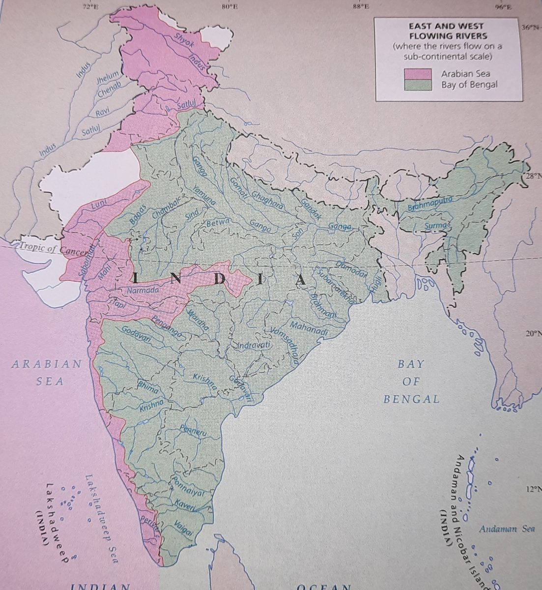
Rivers of India: East and West Flowing Classification
| East Flowing Rivers | West Flowing Rivers |
|---|---|
| Godavari | Narmada |
| Krishna | Tapti |
| Mahanadi | Mahi |
| Kaveri | Sabarmati |
| Brahmaputra | Luni |
| Subarnarekha | – |
| Pennar | – |
| Damodar | – |
| Brahmani | – |
| Ponnaiyar | – |
| Vaigai | – |
Key Characteristics:
- East Flowing Rivers: Drain into the Bay of Bengal
- West Flowing Rivers: Drain into the Arabian Sea
Notable Points:
- Godavari is the longest river in South India, covering 10% of India’s area
- Most east-flowing rivers originate from Western Ghats, Eastern Ghats, and central highlands
- These rivers are crucial for agriculture, irrigation, and supporting biodiversity
Characteristics of South Indian Rivers
• Originate from the Western Ghats
• Short and narrow
• Non-perennial in nature
• Suitable for hydropower generation
• Not useful for navigation
In which river the Gerosappa (jog) fall is found?
Download
1.Rivers in india tnpsc notes pdf (10th New Samacheer Kalvi)
2. Rivers in India Tnpsc notes pdf (10th old Tn Book)
3.Rivers of India and their origin and tributaries PDF Download